“People who are really serious about software should make their own hardware.” –Alan Kay
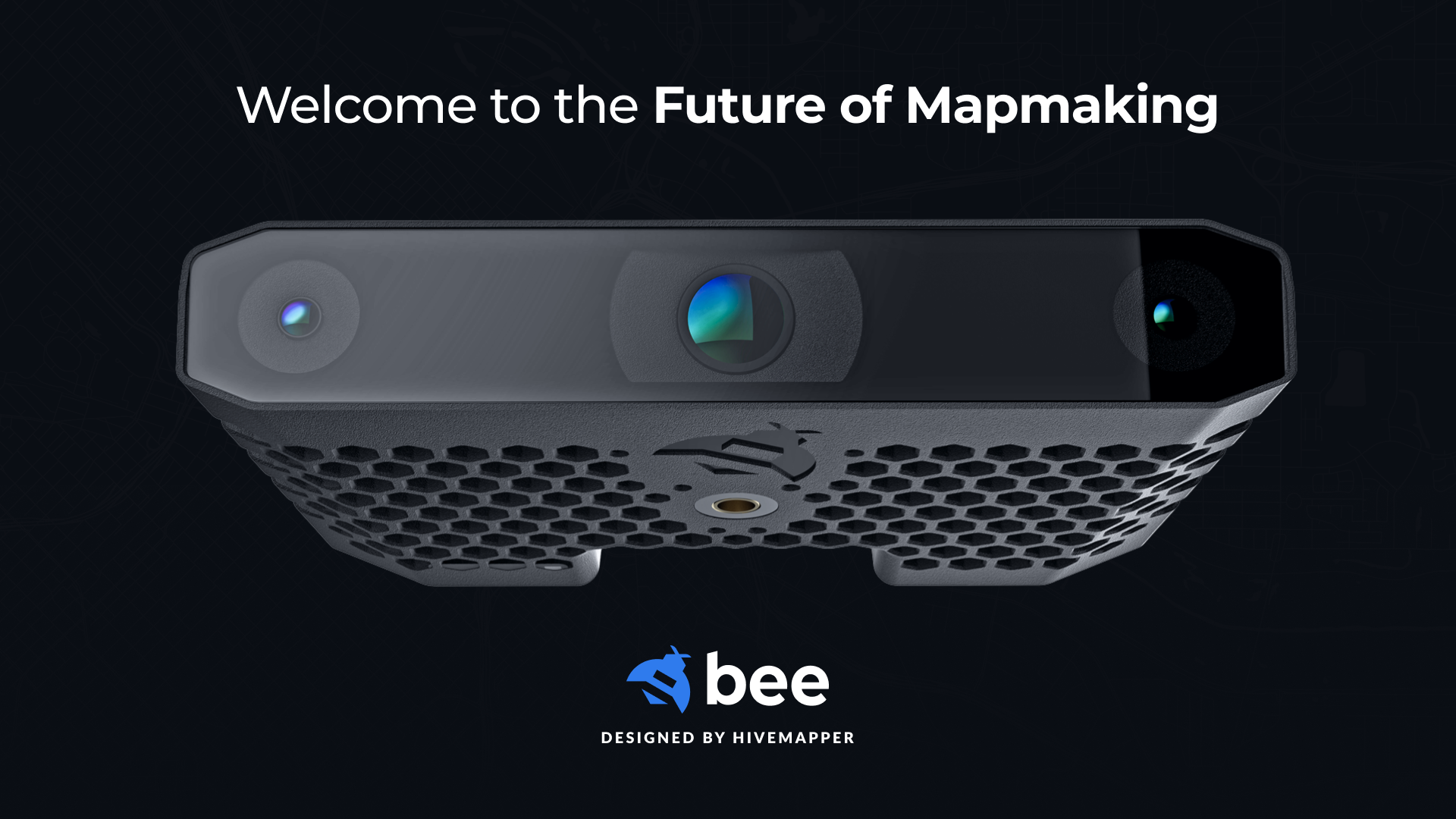
Today, we introduced the Bee.
It’s our most advanced purpose-built mapping camera, capable of passively updating the world’s freshest map. It’s also a premium dashcam that keeps you safe and secure on your daily drives.
We know some people will ask why we bother to design our own hardware instead of using smartphones or off-the-shelf dashcams. It’s a reasonable question; hardware is hard.
You can easily spend millions of dollars designing a hardware device before the first unit rolls off the line. Scaling manufacturing is even harder if you’re doing something new. You often end up in Elon Musk’s “production hell,” like we did with the HDC.
As we chart the path forward for crowdsourced mapping, it would be easier to avoid hardware. But the graveyard of map technology is littered with failed attempts to build maps with smartphone cameras or basic dashcams, for reasons we’ll explain below. Some of the world’s largest app developers have tried and failed.
It would also be easier to say “good enough” and keep selling the current models. We’ve already paid the upfront cost to develop them. We know how to build them. If we were trying to maximize our profit margins, or to flex by adding contributors as quickly as possible, that’s what we’d do.
We won’t take the easy way out. We won’t sacrifice our long-term goals for short-term gain.
We’re here to build fresher and more accurate maps for humanity, and do it in a fairer way.
Here are the reasons why the Bee will help us achieve that mission.
1. 100% passive is the only way
Most Bee Maps contributors want to install a camera in their car, interact with it as little as possible, and earn rewards for helping to build the map.
On the project team, we’re mapping nerds. Some of our most active contributors are mapping nerds too. We love that. But for most people, the perfect user interface is no user interface at all.
That goes tenfold for Bee Maps’ hardworking fleet managers, who need mapping to be dead simple for the drivers they recruit. For most business and public sector fleets, training drivers to manage an app is more than just annoying – it’s a deal-breaker.
When mapping requires effort, drivers give up unless the incentive to keep mapping is very strong. In fact, this has been one of the death blows for smartphone mapping apps, which typically require the user to mount the smartphone and set up the app every time they enter the car. It’s just too much work. People don’t stick with it once the novelty wears off.
Although the HDC and HDC-S are far easier, and have orders of magnitude better productivity as a result, there’s still too much work involved. And the root cause of this is needing to offload map data to a smartphone app.
That changes now. With the Bee, you can finally enjoy 100% passive mapping.
- Every device will offer the option of cellular connectivity, for an added monthly fee.
- Every device will offer direct connectivity to a home or office WiFi router.
- Enhanced edge processing means smaller file sizes – and faster uploads.
Whether you choose a cellular plan or allow the Bee to connect to a WiFi router, the dream of passive mapping is finally here.
2. Doubling down on power and precision
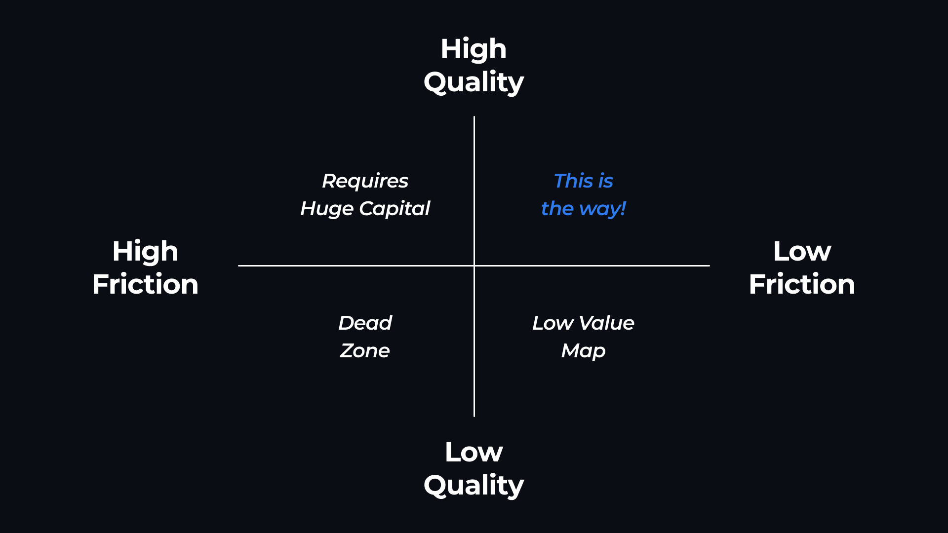
Poor quality has been the fatal flaw of every previous attempt at crowdsourced mapping.
Projects with high friction and low quality fail. In one case we know well, a big tech company acquired a crowdsourced mapping startup. As they dug into the data, they discovered that the poor positional accuracy of the data made it unusable for their use case. So it goes.
A few projects have managed to scale a relatively passive experience using crowdsourced sensors such as basic dashcams, but low-quality data has held them back. Mapping customers have been able to get a little bit of value from these projects … but only a little.
Bee Maps won’t settle for anything less than revolutionizing how maps are made.
From years of experience, we know basic hardware can’t get the job done. Crowdsourced mapping requires more compute power for edge processing, beyond the privacy blurring and basic map processing we do today. Precision positioning requires a higher-end GNSS chip and a bigger antenna than any smartphone could possibly offer.
We’ve chosen every component of the Bee to boost quality along the most important dimensions for mapping compared to our current models. What does that look like?
- Better positioning. We’re adding a larger antenna for more precise baseline positioning, and a dual-band (L1/L5) GNSS chip that offers better support for RTK/PPK corrections.
- Stereo cameras. Detecting a street sign isn’t useful if you can’t say precisely where it is. Stereo cameras make this job much easier, as we proved with the HDC-S. With a wider “baseline” between cameras than the smartphone form factor can offer, the Bee will be able to judge depth just like human eyes can.
- All-season readiness. Mounting a camera outside results in far better imagery and positional accuracy. You’ll be able to do it with confidence with the Bee, which will be sealed to protect against water intrusion and tested to perform in both intensely hot and cold climates.
From a hardware perspective, the Bee is more like the advanced driver assistance systems (ADAS) in a modern car than it is like a dashcam. In the not-too-distant future, we expect a similar hardware and software package to make it into automotive platforms.
3. Mapping on the edge
Bee Maps contributors have mapped a staggering 130 million total kilometers since the launch of the network in November 2022. With one image uploaded for every six to eight meters of driving, that’s 125 images per kilometer and well over 10 billion images uploaded to date.
Do we need all those images to build a map? No, we do not. If we tried to scale this approach to global coverage, we would probably go bankrupt from the cloud computing fees.
Sometimes, uploading images is important. If we haven’t seen a road in a while, the map will benefit from knowing how it looks now – even if nothing has changed as far as we can tell.
But usually, the only question is whether the image helps us improve our understanding of the world – across either the “static” and “dynamic” elements of the map. Static map features are those that rarely change, like traffic lights. Dynamic map features are those that change quickly and affect navigation, such as road debris or a road closure.
We’ve designed the Bee with extremely powerful edge computing capabilities:
- 4GB of RAM
- 4x ARM* A53 (1.5GHz)
- ML Performance: 5.1 TOPS Processor
- Depth sensing optimized
This powerful setup will allow the Bee to process images in real time, beyond the privacy blurring and basic map processing we do today. It will be able to determine whether the network needs a fresh image. It will be able to detect both static (speed limit signs) and dynamic objects (car accidents), position them in space, and send a small payload to the network with metadata and a thumbnail image. Smaller payloads mean faster uploads, lower data charges and lower computing costs for achieving global scale.
That’s efficient. That’s scalable. That’s mapping on the edge.
All in all, powerful hardware devices such as the Bee are critical to achieving the Bee Maps network’s mission of building fresher and more accurate maps, and doing it in a fairer way.
With the Bee, a purpose-built mapping camera, contributors will find it easier than ever to contribute to the network. Their map data will be more precise than ever. And the network will make the best possible use of the computing power of their camera, earning greater rewards in the process. If this wasn't enough, the Bee has premium safety features that help keep you safe and protected on your daily drives.
Follow us on X or Try Bee Maps for Free.