The Latest Buzz
Why Did Hivemapper Design and Build Its Own Cameras?

“People who are really serious about software should make their own hardware.”
It’s the first question many people ask us.
“Why did Hivemapper design and build its own cameras?”
“Why can’t I use my iPhone or Android phone to collect data for the map?”
This wasn’t an easy decision. In fact, we tried to use iPhone and Android devices for an earlier beta version of the Hivemapper Network. We learned that while smartphone mapping sounds smart (it is clearly easier to scale using devices that people already own) the unfortunate reality is that smartphone mapping doesn’t work. Here’s why.
Hivemapper’s dedicated cameras ensure consistent, accurate, and trustworthy mapping data.
Mapping on a global scale requires highly specialized software to:
- Collect data on a global scale
- Process and transform imagery into useful map data
- Create data products (e.g. turn by turn navigation)
If you cannot efficiently collect high quality data, almost nothing else matters. This is why choosing the right hardware is so critical.
Customers care about high-quality and trustworthy data with high levels of coverage that is updated frequently. Contributors want an easy and passive experience — a "set it and forget it" experience. When running a mapping network, it’s critically important that contributors don’t churn, so that you have a stable and consistent set of contributors.
With this in mind, let’s dive into the rationale that led us to design and build cameras.
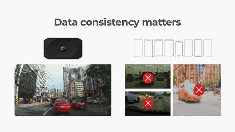
1. Customers love consistent imagery
We always start with the customer’s needs. Map customers love standardized street-level imagery, since they often feed the imagery to machine-learning algorithms to detect objects (signs, lane markings, etc.).
If we allowed contributors to use their own iPhone/Android, we would be dealing with endless image variations, which customers dislike because it increases the amount of work they need to do in order to use the imagery.
2. Customers really like accurate maps
It turns out that customers also really like accurate maps. The GPS in your phone just isn’t accurate enough for high-quality mapping. You’ve likely experienced this when using Google Maps / Waze. Your phone will sometimes think you’re driving on a nearby service road when in fact you’re on the highway. For reliable mapping, this is unworkable.
If you incorrectly position a speed limit sign by a few meters, it becomes impossible to know if that sign applies to the highway or the service road. That's dangerous, and customers won't use your map data for very long.
When dealing with literally ten billion objects, if your errors only apply to 5% of objects that means hundreds of millions of objects are incorrectly positioned. When that happens, the value of the data drops exponentially, especially for mission-critical use cases like navigation and autonomous systems.
Ultimately, the real value drivers and moats are achieving high level of positional accuracy across the long long tail of edge cases.
We are continuously working to improve the positional accuracy of the imagery as we develop future firmware releases and new dashcam models.
3. Customers need to trust the data
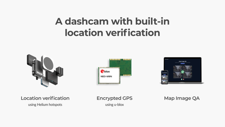
The GPS in your phone can be easily spoofed. As a map, it’s critical that we be able trust the collected data. Without trust, things break down quickly. We have built multiple layers of location-verification security into the dashcam, and may add more over time.
4. Set it and forget it experience for contributors
When using 3rd party hardware and/or smartphones you don't really control the experience for contributors and that means it is impossible to achieve the holy grail of truly passive data and imagery collection at scale.
When using a smartphone to map, for *every* trip a driver takes they need to mount their phone properly, open the app, and then hit “start.” When rushing to the airport or jumping in the car to grab a coffee with a friend, we know from firsthand experience that people quickly forget to mount their phone, open the app, and hit start mapping.
In contrast, Hivemapper's device is fully automated and frictionless for contributors. More on this later this month.
5. Able to map in extreme weather conditions
If you’ve ever left your phone near your dashboard on a hot summer day in Vegas or Arizona, you know that it can quickly overheat and automatically turn itself off. Turns out that people find this incredibly frustrating that they need to wait 20 minutes for their phone to cool down and reboot.
The Hivemapper Dashcam has mapped in 105 degree weather for 8 hours per day, and never once had issues.
6. Edge processing is critical to making the economics work
It is true that smartphones have plenty of compute and sensors, but they don't have the right compute and sensors for mapmaking.
In fact, one of the large mobile smartphone platform companies tried building maps from smartphones, and ultimately shut down the program.
You need to have the correct set of sensors and compute to move 100% of processing to the edge as this dramatically lowers compute costs and makes the economics viable. Let's take a quick look at the right hardware needed:
(a) Stereo depth cameras are key as they can accurately determine the exact location of an object e.g. speed limit sign.
(b) The baseline distance between the stereo cameras is critical - the wider the better, in most cases.
(c) GNSS (GPS) module and antenna - you need an L1/L5 dual band GNSS module with the correctly sized antenna placed correctly in the device to ensure that it can see the satellites in the sky.
(d) Local Authentication - given there are clear incentives to map with Hivemapper that obviously attracts bad actors, and authentication is built into the hardware to verify that the data collected is authentic to the space and time.
(e) Wide angle camera - the middle camera needs a wide angle to see both sides of the street, while not losing pixels at the edges of the image.
We can go on, but now we are in the territory of a longer blog post.
7. Exterior-mounted dashcams produce higher quality data
Exterior-mounted dashcams produce high-quality imagery and positional accuracy. Mounting an iPhone or Android phone outside of your vehicle is a good way to destroy your phone rather quickly.
8. The Play Store Risk
We are building the world’s freshest global map, and it’s no secret that one of Google’s crown jewels is Google Maps. The expansion of our mapping network and growth of our map is something Google is not be thrilled about. And they would likely do something to protect their investment in Google Maps.
If we primarily collected data via an Android app, Google could begin to nefariously delay update approvals of our Android app on the Play Store, or worse yet, remove it from the Play Store entirely.
To be clear, this is not the primary reason we built our own cameras — it’s a low probability scenario. But by doing so, we reduce this long-term risk to the project and the businesses that depend on it.
__
Follow us on X (Twitter) and join the community on Discord.
Share Post


